

Asian Longhorned Beetle Field Technician, Worcester, MA
APPLICATION DEADLINE: April 19, 2013 Wage: $10/hour Season: June 1 to September 30, 2013 Job Description We are looking for a full-time assistant to help...
By Maja Cannavo
Here at Green Goat Maps, we’re creating a new map design dedicated specifically to mountain biking! We haven’t decided on a location yet, but we’ve been thinking a lot about where would be best.
We scoured the internet for mountain bike maps, both in print form and online, and dug out all the ones we already had on hand. We found maps from across the country and overseas. There were a variety of maps out there—they range in scope from ski mountains to a 100+ mile thru-trail; their designs ranged from being specifically for mountain bike festivals to being meticulously researched and marketed for broad distribution. Many were good, many were bad—but they all ultimately helped guide our new trail design.
There were a couple of maps that really stood out for certain reasons. For example, we loved the detailed loop information in National Geographic’s Buffalo Creek Mountain Bike Trails map, but not the detail of the trails on the map. We were inspired by the terrain illustrations on the Telluride mountain bike trail map, but we felt that it could benefit from more topographical detail. Another great map was the Allegrippis Trails Map and Guide, with its trail features information like rollers and banked flow trails. These are just a few of the maps we looked at, and they inspired us to create our own design that met the needs of the mountain biking community.
We answered 20 specific questions for each map relating to trail symbology and labeling, terrain and topography, natural and built features, scale and detail, legend and symbols, additional mountain biking information, and layout/insets. Some were simple yes-or-no questions (for example, “Does the map include other types of trails besides those used for mountain biking?”), while others were more detailed (for instance, one question asked about the level of information given for individual loops).
The two maps that did the best were the National Geographic Buffalo Creek Mountain Bike Trails map and an international map, the Chamonix-Mont-Blanc Mountain Biking Trails map. Buffalo Creek scored well because of its professional appearance, incredible detail, and wealth of information. We liked Chamonix-Mont-Blanc because of its detailed individual trail illustrations and descriptions.
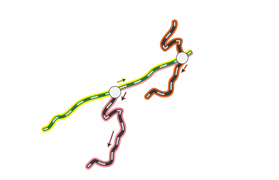
Armed with the results of our evaluation, we are ready to create our own mountain-biking-specific map. We have a preliminary design in the works, using green, blue, and black trail colors to denote difficulty ratings and using bright-colored outlines to mark different recommended routes. Check out the example on the right! Or, better yet, grab a copy of our new Old Forge Area Outdoor Adventure Map when it hits the shelves in a few weeks! We’ve included a mountain-biking-specific inset for the McCauley Mountain and Maple Ridge trail network that uses our new design.
APPLICATION DEADLINE: April 19, 2013 Wage: $10/hour Season: June 1 to September 30, 2013 Job Description We are looking for a full-time assistant to help...
This position has been filled. APPLICATION DEADLINE: April 19, 2013 Wage: $12/hour Season: May 10 to August 25, 2013 Job Description We are looking for a part-time...
The tree-devouring Asian longhorned beetle has not yet been driven from the gates of the city, but, by Jove, pest-control...
Saranac Lake, N.Y. - Adirondack Research, LLC, a Saranac Lake-based ecological research firm, has been awarded a contract with the...
As a way to continually give back to our community and to the organizations we wish to support, Adirondack Research...
Please check out the species regulations Adirondack Research helped to inform. We are responsible for the assessments on all of...
Read the newest peer-reviewed journal article by Ezra Schwartzberg published in Functional Ecology. The title is "Aphid honeydew alters plant...