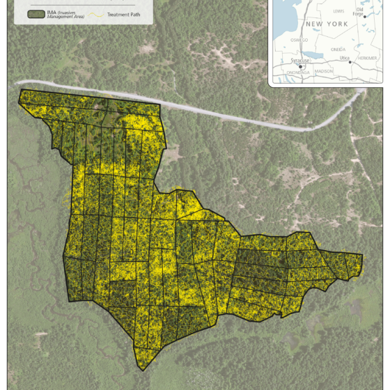
Fort Drum – Cantonment Area Herbicide Application
Adirondack Research implemented a large-scale understory invasive species management program across the cantonment area of Fort Drum, treating approximately 64 acres across multiple Invasive Management Areas (IMAs). The project focused on reducing dense invasive shrub layers to support native regeneration, improve forest structure, and enhance habitat conditions within highly managed landscapes. Design map to emphasize treatment intensity, spatial coverage, and operational...
Fort Drum Beech Control – Hack-and-Squirt Herbicide Treatment
American beech (Fagus grandifolia) can become an undesirable species in managed forest systems when it forms dense understory thickets that suppress regeneration of desired tree species. At Fort Drum, this condition is common in previously harvested areas, where beech root sprouting has resulted in high-density regeneration that limits forest diversity and habitat quality. In 2025, Adirondack Research partnered with Atlas Contracting...
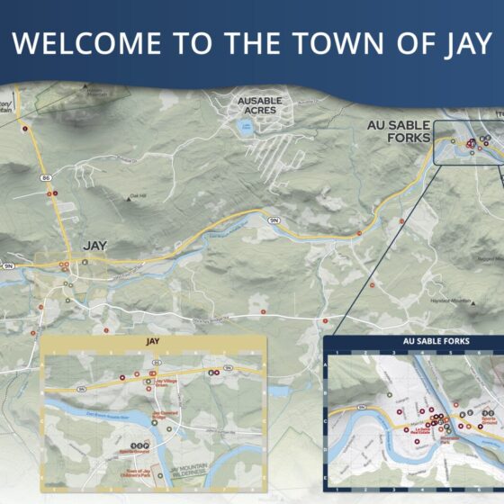
Town of Jay Wayfinding Map and Kiosk
About the Project We worked with our client, the Regional Office for Sustainable Tourism (ROOST) in partnership with the Town of Jay to create a kiosk map showing the three villages of Upper Jay, Jay, and Au Sable Forks. The purpose for this map and kiosk display was to help support the tourism economy in the Whiteface Region of...
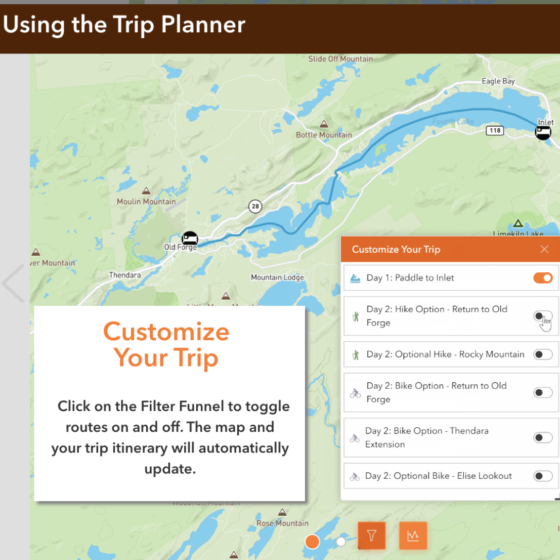
Hamlets to Huts Website Maps
We worked with Hamlets to Huts to design several multi-day outdoor trips. These interactive maps feature daily itineraries and direct instructions so travelers can safely navigate the Adirondack backcountry waterways. Fulton Chain Circuit - Paddle and Bike: Blue Mountain Lake Paddle Traverse: Raquette Lake Loop:

Peconic River - Long-Term Pre & Post Treatment Surveys
Invasive species are any kind of living organism that is not native to an ecosystem and causes some sortof ecological, human health, or socio-economic harm. In 2022, Adirondack Research, a private researchand mapmaking firm, contracted with the New York State Department of Environmental Conservation(NYSDEC) to survey portions of the Peconic River over a five-year period between 2022 and 2025. In2022,...
2022 Horseshoe Pond AIS Survey - Procella COR Permitting Report
We performed an aquatic invasive species (AIS) and native aquatic plant species survey for Horseshoe Pond, in Franklin County on August 8th-9th 2022. This survey was completed in preparation for The Horseshoe Pond - Deer River Flow Association applying to the Adirondack Park Agency for a permit to use the herbicide ProcellaCOR EC for the control of an aquatic pest...

Ezra Schwartzberg. Ph.D.
CEO
Ezra is originally from Saranac Lake and spent 10 years working in academia in Kentucky, Pennsylvania and Wisconsin. Ezra moved back to Saranac Lake in 2012 with a goal to use his passion for research to improve regional social and environmental issues.
Ezra uses research expertise to guide our processes, including program design, data analysis and project evaluation. By combining ecological research with print and digital media, Adirondack Research is able to communicate science to help our clients reach their policy goals.
Ezra’s work with the Intervale Lowlands Preserve in Lake Placid recently won an Environmental Excellence Award from the New York State Department of Environmental Conservation and his work with Adirondack Council and Adirondack Action is changing the way policy advocates use science in state and regional decision-making.
Ezra’s Curriculum Vita can be viewed here
Roman Perkhaliuk

Boris Vitlic

Randall Swanson
Louise Gava