
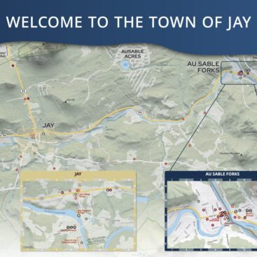
Town of Jay Wayfinding Map and Kiosk
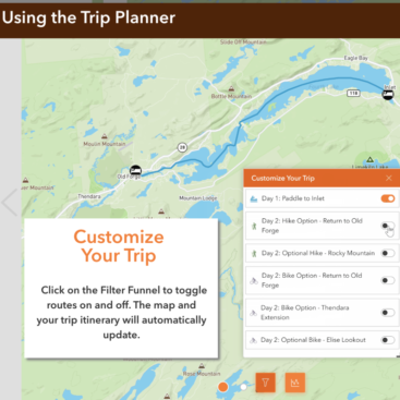
Hamlets to Huts Website Maps
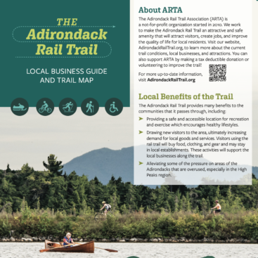
Adirondack Rail Trail Map and Brochure
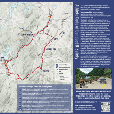
Ironman Athlete Map and Conduct Guide
Town of Franklin Signage
Viall’s Crossing Signage


Town of Jay Wayfinding Map and Kiosk
About the Project We worked with our client, the Regional Office for Sustainable Tourism (ROOST) in partnership with the Town of Jay to create a kiosk map showing the three villages of Upper Jay, Jay, and Au Sable Forks. The purpose for this map and kiosk display was to help support the tourism economy in the Whiteface Region of...
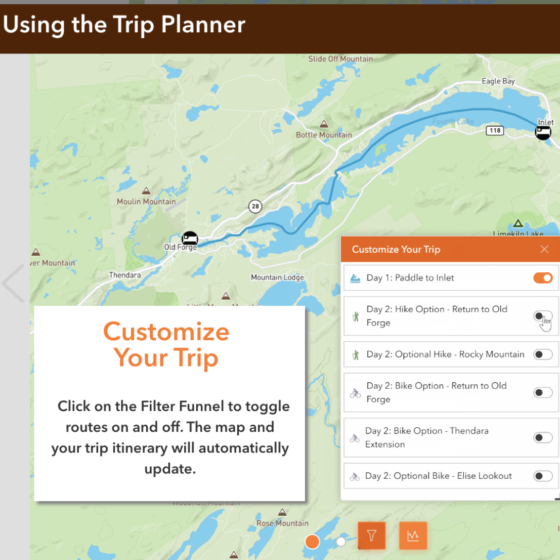
Hamlets to Huts Website Maps
We worked with Hamlets to Huts to design several multi-day outdoor trips. These interactive maps feature daily itineraries and direct instructions so travelers can safely navigate the Adirondack backcountry waterways. Fulton Chain Circuit - Paddle and Bike: Blue Mountain Lake Paddle Traverse: Raquette Lake Loop:
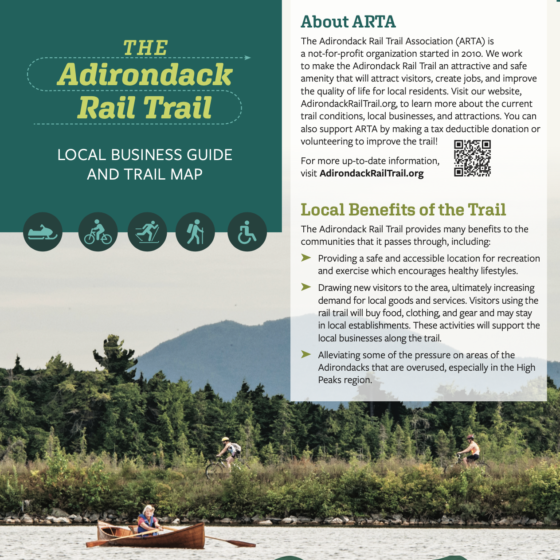
Adirondack Rail Trail Map and Brochure
We created a map and tri-fold brochure for the Adirondack Rail Trail Association (ARTA) to update people on the current status of the rail-trail project now that it is partially usable. ARTA needed a brochure and map to show where the trail is, when it will be completed, and what businesses are in the community to support trail users. We...

Ironman Athlete Map and Conduct Guide
We were contracted by IRONMAN to create an Athlete Conduct Map and Guide for the 2022 IRONMAN. IRONMAN’s goal for this project is to help athletes discover and explore a variety of communities along the cycling route and to educate them on safe practices on the roads. This is part of an effort to respond to the concerns about the...

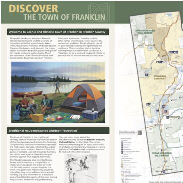
Town of Franklin Signage
We created kiosks for the Town of Franklin that feature the outdoor recreational opportunities available in the town. The map includes snowmobile trails, hiking trails, lakefront campsites, and road cycling routes. The kiosks highlight Kate Mountain Park and the Buck Pond Campground and Day Use Area. In addition, the kiosk shares information about the Haudenosaunee and the Six Nations Iroquois...
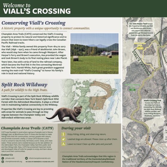
Viall's Crossing Signage
We created a new map and kiosk insert for the Champlain Area Trails(CATS) at Viall’s Crossing. The sign and map highlight the regional trail system as well as the trail’s access to the Westport business district. The map and kiosk will also educate users on improvements to the trails in the area that CATS is performing and will help users...
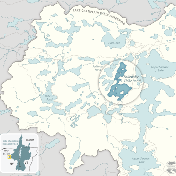
Upper Saranac Foundation Grant Application and Report Maps
These maps were created for grant applications and grant reports for the Upper Saranac Foundation's milfoil management efforts on Upper Saranac Lake and Follensby Clear Pond. Client: Upper Saranac Foundation Medium: Digital Assets) Size: Website and print. Attribution: Nicole Keating was the cartographer and graphic designer.
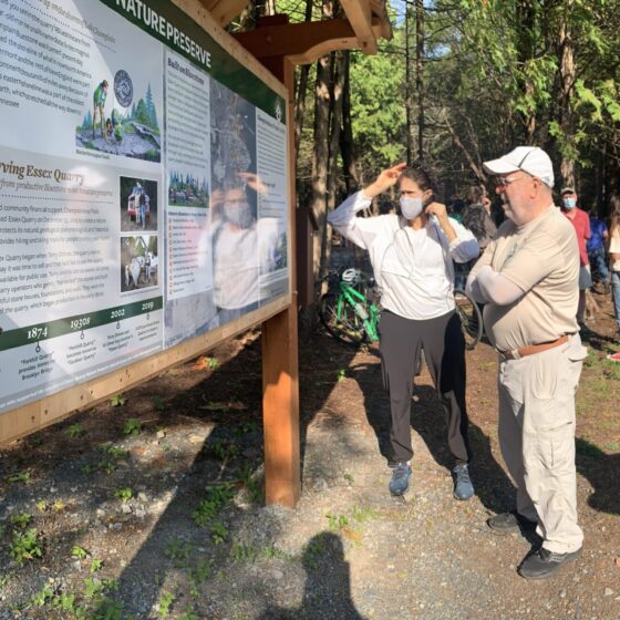
Essex Quarry Nature Preserve Signage
These on-trail interpretive signs were created for Champlain Area Trails (CATS) to help teach visitors of Essex Quarry Nature Preserve about the natural and social history of the preserve. This project included a main kiosk display and map, a tri-fold brochure and map, on-trail wayfinding maps, and six interpretive panels. Client: Champlain Area Trails Medium: Vinyl wrapped DiBond mounted on a...
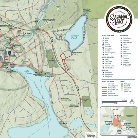
Wayfinding Maps for Saranac Lake
Adirondack Research was tasked with drafting a new map that would cater to residents and visitors and complement the DRI funding's infrastructure enhancements. The map needed to provide clear wayfinding information, be aesthetically appealing, and support the principles and standards of the Village's Complete Streets Policy. The new maps were created from scratch using cartographic software that showcased the uniqueness of...
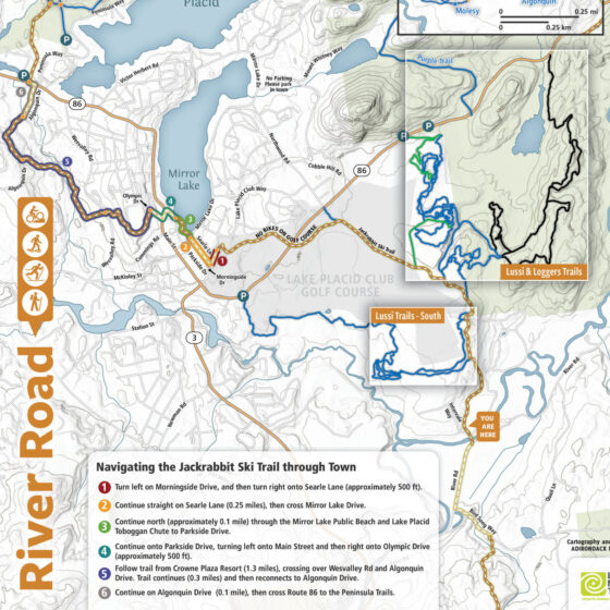
Trailhead Kiosks on Jackrabbit Ski Trail
These way-finding and informational signs were designed for BETA to enhance the trail users' experience by aiding in way-finding, providing information on trail usage rules and regulations, trail etiquette, and on the history and role of the Barkeater Trails Alliance in building and maintaining trails in the region.